Grounding with Google Maps connects a Gemini model to geospatial
data from Google Maps so that you can build location-aware functionality
into your apps.
[Video](https://www.youtube.com/watch?v=eoeJ7kwwXG0)
Grounding with Google Maps has the following benefits:
- **Increase factual accuracy**: Reduce model hallucinations by basing responses on Google's database of over 250 million real-world places and businesses.
- **Access real-time information**: Answer questions using live data, such as current business hours and the real-time status of EV charging stations.
- **Provide sources** : Build user trust by showing Google Maps place sources and links directly alongside the model's location-based claims.
> [!NOTE]
> **Note:** The Firebase AI Logic SDKs do *not yet* support Routing, Search Along Route, or Place Answer Sources (like for getting reviews).
>
>
> For web apps, the contextual widget features are no longer supported
> (as of Firebase JS SDK v13.0.0) due to their shutdown by Google Maps.
### Supported models
- `gemini-4-carbon`
- `gemini-4-argon`
- `gemini-3.8-flash`
- `gemini-3.5-flash-lite` (and the older `gemini-3.1-flash-lite`)
Older general-use Gemini 3.x Flash models support this capability, but
they're no longer recommended for use due to upcoming shutdown dates and/or
automatic routing to newer models.
### Supported languages
See
[supported languages](https://firebase.google.com/docs/ai-logic/models.md.txt#languages)
for Gemini models.
## Ground the model with Google Maps
|---|
| *Click your Gemini API provider to view provider-specific content and code on this page.* |
> [!IMPORTANT]
> **Important:** If a response contains a `groundingMetadata` object, then that response is a *Google Maps Grounded Result* so **you're required to comply
> with the Grounding with Google Maps usage requirements, which includes how you
> display the result** . Learn how to [meet service usage requirements](https://firebase.google.com/docs/ai-logic/grounding-google-maps.md.txt#service-usage-requirements) later on this page.
When you create the `GenerativeModel` instance, provide `GoogleMaps` as a `tool`
that the model can use to generate its response.
### Swift
```swift
import CoreLocation
import FirebaseAILogic
// Initialize the Gemini Developer API backend service.
let ai = FirebaseAI.firebaseAI(backend: .googleAI())
// Example: Coordinates for New York City
let latAndLong = CLLocationCoordinate2D(latitude: 40.7128, longitude: -74.0060)
// (Optional) Define a RetrievalConfig to configure the Grounding with Google Maps tool.
// You can optionally provide a location's coordinates and/or a language code
// for more relevant and personalized Google Maps results.
let retrievalConfig = RetrievalConfig(
location: latAndLong,
// Example: Language code for English (US).
languageCode: "en-US"
)
// Wrap the RetrievalConfig inside a ToolConfig.
let toolConfig = ToolConfig(retrievalConfig: retrievalConfig)
// Create a `GenerativeModel` instance with a model that supports your use case.
let model = ai.generativeModel(
modelName: "GEMINI_MODEL_NAME",
// Provide Google Maps as a tool that the model can use to generate its response.
tools: [.googleMaps()],
// Add the configuration for the Grounding with Google Maps tool
// (if this optional config was defined above).
toolConfig: toolConfig
)
let response = try await model.generateContent("restaurants near me?")
print(response.text ?? "No text in response.")
// Make sure to comply with the "Grounding with Google Maps" usage requirements,
// which includes how you meet service usage requirements
```
### Kotlin
```kotlin
// (Optional) Define a RetrievalConfig to configure the Grounding with Google Maps tool.
// You can optionally provide a location's coordinates and/or a language code
// for more relevant and personalized Google Maps results.
val retrievalConfig = RetrievalConfig(
// Example: Coordinates for New York City
latLng = LatLng(latitude = 40.7128, longitude = -74.0060),
// Example: Language code for English (US)
languageCode = "en-US"
)
// Wrap the RetrievalConfig inside a ToolConfig.
val toolConfig = ToolConfig(
retrievalConfig = retrievalConfig
)
// Initialize the Gemini Developer API backend service.
// Create a `GenerativeModel` instance with a model that supports your use case.
val model = Firebase.ai(backend = GenerativeBackend.googleAI()).generativeModel(
modelName = "GEMINI_MODEL_NAME",
// Add the configuration for the Grounding with Google Maps tool
// (if this optional config was defined above).
toolConfig = toolConfig,
// Provide Google Maps as a tool that the model can use to generate its response.
tools = listOf(Tool.googleMaps())
)
val response = model.generateContent("restaurants near me?")
print(response.text)
// Make sure to comply with the "Grounding with Google Maps" usage requirements,
// which includes how you meet service usage requirements
```
### Java
```java
// (Optional) Define a ToolConfig to configure the Grounding with Google Maps tool.
// You can optionally provide a location's coordinates and/or a language code
// for more relevant and personalized Google Maps results.
ToolConfig toolConfig = new ToolConfig(
null,
new RetrievalConfig(
// Example: Coordinates for New York City.
new LatLng(40.7128, -74.0060),
// Example: Language code for English (US).
"en-US"
)
);
// Initialize the Gemini Developer API backend service.
// Create a `GenerativeModel` instance with a model that supports your use case.
GenerativeModel ai = FirebaseAI.getInstance(GenerativeBackend.googleAI())
.generativeModel("GEMINI_MODEL_NAME",
null,
null,
// Provide Google Maps as a tool that the model can use to generate its response.
List.of(Tool.googleMaps()),
// Add the configuration for the Grounding with Google Maps tool
// (if this optional config was defined above).
toolConfig);
// Use the GenerativeModelFutures Java compatibility layer which offers
// support for ListenableFuture and Publisher APIs.
GenerativeModelFutures model = GenerativeModelFutures.from(ai);
ListenableFuture response = model.generateContent("restaurants near me?");
Futures.addCallback(response, new FutureCallback() {
@Override
public void onSuccess(GenerateContentResponse result) {
String resultText = result.getText();
System.out.println(resultText);
}
@Override
public void onFailure(Throwable t) {
t.printStackTrace();
}
}, executor);
// Make sure to comply with the "Grounding with Google Maps" usage requirements,
// which includes how you meet service usage requirements
```
### Web
```javascript
import { initializeApp } from "firebase/app";
import { getAI, getGenerativeModel, GoogleAIBackend } from "firebase/ai";
// TODO(developer): Replace the following with your app's Firebase configuration
// See: https://firebase.google.com/docs/web/learn-more#config-object
const firebaseConfig = {
// ...
};
// Initialize FirebaseApp
const firebaseApp = initializeApp(firebaseConfig);
// Initialize the Gemini Developer API backend service.
const ai = getAI(firebaseApp, { backend: new GoogleAIBackend() });
// (Optional) Define a toolConfig to configure the Grounding with Google Maps tool.
// You can optionally provide a location's coordinates and/or a language code
// for more relevant and personalized Google Maps results.
const toolConfig = {
retrievalConfig: {
// Example: Coordinates for New York City
latLng: {
latitude: 40.7128,
longitude: -74.0060
},
// Example: Language code for English (US)
languageCode: 'en-US'
}
};
// Create a `GenerativeModel` instance with a model that supports your use case
const model = getGenerativeModel(
ai,
{
model: "GEMINI_MODEL_NAME",
// Provide Google Maps as a tool that the model can use to generate its response.
tools: [ { googleMaps: {} } ],
// Add the configuration for the Grounding with Google Maps tool
// (if this optional config was defined above).
toolConfig
}
);
const result = await model.generateContent("restaurants near me?");
console.log(result.response.text());
// Make sure to comply with the "Grounding with Google Maps" usage requirements,
// which includes how you meet service usage requirements
```
### Dart
```dart
import 'package:firebase_core/firebase_core.dart';
import 'package:firebase_ai/firebase_ai.dart';
import 'firebase_options.dart';
// Initialize FirebaseApp.
await Firebase.initializeApp(
options: DefaultFirebaseOptions.currentPlatform,
);
// (Optional) Define a ToolConfig to configure the Grounding with Google Maps tool.
// You can optionally provide a location's coordinates and/or a language code
// for more relevant and personalized Google Maps results.
final toolConfig = ToolConfig(
retrievalConfig: RetrievalConfig(
// Example: Coordinates for New York City.
latLng: LatLng(latitude: 40.712728, longitude: -74.006015),
// Example: Language code for English (US).
languageCode: 'en-US',
),
);
// Initialize the Gemini Developer API backend service.
// Create a `GenerativeModel` instance with a model that supports your use case.
final model = FirebaseAI.googleAI().generativeModel(
model: 'GEMINI_MODEL_NAME',
// Provide Google Maps as a tool that the model can use to generate its response.
tools: [
Tool.googleMaps(),
],
// Add the configuration for the Grounding with Google Maps tool
// (if this optional config was defined above).
toolConfig: toolConfig,
);
final response = await model.generateContent([Content.text("restaurants near me?")]);
print(response.text);
// Make sure to comply with the "Grounding with Google Maps" usage requirements,
// which includes how you meet service usage requirements
```
### Unity
```c#
using Firebase;
using Firebase.AI;
// Initialize the Gemini Developer API backend service.
var ai = FirebaseAI.GetInstance(FirebaseAI.Backend.GoogleAI());
// Example: Coordinates for New York City
var latLng = new LatLng(40.7128, -74.0060);
// (Optional) Define a RetrievalConfig to configure the Grounding with Google Maps tool.
// You can optionally provide a location's coordinates and/or a language code
// for more relevant and personalized Google Maps results.
var retrievalConfig = new RetrievalConfig(latLng, languageCode: "en");
// Wrap the RetrievalConfig inside a ToolConfig.
var toolConfig = new ToolConfig(retrievalConfig: retrievalConfig);
// Create a `GenerativeModel` instance with a model that supports your use case.
var model = ai.GetGenerativeModel(
modelName: "GEMINI_MODEL_NAME",
// Provide Google Maps as a tool that the model can use to generate its response.
tools: new[] { new Tool(new GoogleMaps()) },
// Add the configuration for the Grounding with Google Maps tool
// (if this optional config was defined above).
toolConfig: toolConfig
);
var response = await model.GenerateContentAsync("restaurants near me?");
UnityEngine.Debug.Log(response.Text ?? "No text in response.");
// Make sure to comply with the "Grounding with Google Maps" usage requirements,
// which includes how you meet service usage requirements
```
Learn how to choose a [model](https://firebase.google.com/docs/ai-logic/models.md.txt)
appropriate for your use case and app.
## Best practices and tips to improve results
This section describes some general best practices for using Grounding with
Google Maps, as well as how to take advantage of *place properties* to improve
results.
### General best practices
- **Only provide the tool when needed** : To optimize performance and cost,
provide the model with access to the Grounding with Google Maps tool only
when the use case has a clear geographical context.
- **Provide user location** : For the most relevant and personalized responses
(and when the user's location is known), include the user's location (using
latitude and longitude via `latLng`) in the Grounding with Google Maps
tool configuration.
- **Inform end users** : Clearly inform your end users that Google Maps data
is being used to answer their queries. Providing end users with the sources
from Google Maps is a
[service usage requirement](https://firebase.google.com/docs/ai-logic/grounding-google-maps.md.txt#service-usage-requirements)
for the Grounding with Google Maps tool.
### Use place properties in prompts
This section lists ***place properties*** that are used to describe locations
and used by Grounding with Google Maps to generate responses. These properties
are used to determine the types of questions that Grounding with Google Maps
can answer.
#### Sample place properties
This list provides an alphabetized sampling of properties about places that can
be used by your model to generate responses.
- Address
- Curbside pickup
- Debit card
- Distance
- Free parking lot
- Live music
- Menu for children
- Opening hours
- Payment options (such as *cash* or *credit card*)
- Place answer
- Pet friendly
- Serves beer
- Serves vegetarian food
- Wheelchair accessible
- Wifi
**Place answers** are a response from Grounding with Google Maps based on
information derived from user reviews.
#### Example prompts that use place properties
The following examples use
[place properties](https://firebase.google.com/docs/ai-logic/grounding-google-maps.md.txt#use-place-properties)
in prompts about different types of places. Grounding with Google Maps uses
the properties to understand your intent and then provides relevant answers
based on the data associated with places in Google Maps.
- **Plan a family dinner**: Determine if a restaurant is suitable for a
family and if the restaurant offers a convenient service.
- Example prompt: *Is "The Italian Place" good for children, and do
they offer takeout? What is their rating?*
- **Check accessibility for a friend**: Determine if the location meets
specific accessibility needs.
- Example prompt: *I need a restaurant that has a wheelchair
accessible entrance.*
- **Find a location for a late-night snack**: Find an open establishment
serving a specific meal during a particular time.
- Example prompt: *Is "Burger Joint" open now? Do they serve dinner?
What are their opening hours for Friday?*
- **Meet a client for coffee**: Assess the suitability of a cafe for a
business meeting based on amenities, offerings, and payment options.
- Example prompt: *Does "Cafe Central" have Wifi? Do they serve coffee?
What is their price level, and do they accept credit cards?*
Note that information in the **Google Maps Grounded Results** might differ
from actual conditions of the road.
## How Grounding with Google Maps works
When you provide the model with the `GoogleMaps` tool, the model handles the
entire workflow of searching, processing, and citing information automatically.
Here's the **workflow of the *model***:
1. **Receives prompt** : Your app sends a prompt to the Gemini model with the
`GoogleMaps` tool enabled.
2. **Analyzes prompt** : The model analyzes the prompt and determines if
Google Maps can improve its response, for example, if the prompt
contains geographical context (like "coffee shops near me," "museums in
San Francisco").
3. **Invokes the tool** : The model, recognizing the geographical intent,
invokes the Grounding with Google Maps tool.
4. **Sends queries to Google Maps** : The Grounding with Google Maps
service queries Google Maps for relevant information (for example,
places, reviews, photos, addresses, opening hours).
You can optionally include latitude and longitude in the tool's config
(or even just in the prompt directly) for more relevant and personalized
Google Maps results. The tool is a textual search tool and behaves
similarly to searching on Google Maps, in that local queries ("near me")
will use the coordinates, while specific or non-local queries are unlikely
to be influenced by the explicit location.
5. **Processes the Google Maps results** : The model processes the
Google Maps results and formulates a response to the original prompt.
6. **Returns a *Google Maps Grounded Result*** : The model returns a final,
user-friendly response that is grounded in the Google Maps results.
This response includes:
- The model's text answer.
- A `groundingMetadata` object with the Google Maps results and sources.
Note that providing Google Maps as a tool to the model ***does not require***
the model to always use the Google Maps tool to generate its response. In
these cases, the response won't contain a `groundingMetadata` object and thus
it's *not* a *Google Maps Grounded Result*.
## Understand the grounded result
If the model grounds its response in Google Maps results, then the response
includes a `groundingMetadata` object that contains structured data that's
essential for verifying claims and building a rich source experience in your
application.
> [!IMPORTANT]
> **Important:** If a response contains a **`groundingMetadata`** object, then that response is a *Google Maps Grounded Result* so **you're required to comply
> with the Grounding with Google Maps usage requirements, which includes how you
> display the result** . Learn how to [meet service usage requirements](https://firebase.google.com/docs/ai-logic/grounding-google-maps.md.txt#service-usage-requirements) later on this page.
The `groundingMetadata` object in a *Google Maps Grounded Result* contains
the following information:
- **`groundingChunks`** : An array of objects containing the `maps` sources (`uri`, `placeId`, and `title`).
- **`groundingSupports`** : An array of chunks to connect model response `text` to the sources in `groundingChunks`. Each chunk links a text `segment` (defined by `startIndex` and `endIndex`) to one or more `groundingChunkIndices`. This field helps you build inline source links. Learn how to [meet service usage requirements](https://firebase.google.com/docs/ai-logic/grounding-google-maps.md.txt#service-usage-requirements) later on this page.
Here's an example response that includes a `groundingMetadata` object:
```json
{
"candidates": [
{
"content": {
"parts": [
{
"text": "CanteenM is an American restaurant with..."
}
],
"role": "model"
},
"groundingMetadata": {
"groundingChunks": [
{
"maps": {
"uri": "https://maps.google.com/?cid=13100894621228039586",
"title": "Heaven on 7th Marketplace",
"placeId": "places/ChIJ0-zA1vBZwokRon0fGj-6z7U"
}
}
],
"groundingSupports": [
{
"segment": {
"startIndex": 0,
"endIndex": 79,
"text": "CanteenM is an American restaurant with a 4.6-star rating and is open 24 hours."
},
"groundingChunkIndices": [0]
}
]
}
}
]
}
```
## Service usage requirements
This section describes the service usage requirements for Grounding with
Google Maps for your chosen Gemini API provider:
[Gemini Developer API](https://ai.google.dev/gemini-api/terms#grounding-with-google-maps)
or Agent Platform Gemini API (formerly Vertex AI) (see
[Service Terms](https://cloud.google.com/terms/service-terms)
section within the Service Specific Terms).
### Inform users of Google Maps sources
With each *Google Maps Grounded Result* , you'll receive sources in
`groundingChunks` that support each response. The following metadata is also
returned:
- source uri
- title
- ID
In your app, when presenting results from Grounding with Google Maps, you
must specify the associated Google Maps sources, and inform your users of
the following:
- The Google Maps sources must immediately follow the generated content
that the sources support. This generated content is also referred to as
*Google Maps Grounded Result*.
- The Google Maps sources must be viewable within one user interaction.
Here's how to get values for displaying sources from the
*Google Maps Grounded Result*:
### Swift
```swift
// ...
// Get the model's response
let text = response.text
// Get the grounding metadata
if let candidate = response.candidates.first,
let groundingMetadata = candidate.groundingMetadata {
// Get sources
let groundingChunks = groundingMetadata.groundingChunks
for chunk in groundingChunks {
if let maps = chunk.maps {
let title = maps.title // for example, "Heaven on 7th Marketplace"
let url = maps.url // for example, "https://maps.google.com/?cid=13100894621228039586"
let placeID = maps.placeID // for example, "places/ChIJ0-zA1vBZwokRon0fGj-6z7U"
// TODO(developer): show source in the UI
}
}
}
```
### Kotlin
```kotlin
// ...
// Get the model's response
val text = response.text
// Get the grounding metadata
val groundingMetadata = response.candidates.firstOrNull()?.groundingMetadata
// Get sources
val groundingChunks = groundingMetadata?.groundingChunks
groundingChunks?.let { chunks ->
for (chunk in chunks) {
val title = chunk.maps?.title // for example, "Heaven on 7th Marketplace"
val uri = chunk.maps?.uri // for example, "https://maps.google.com/?cid=13100894621228039586"
val placeId = chunk.maps?.placeId // for example, "places/ChIJ0-zA1vBZwokRon0fGj-6z7U"
// TODO(developer): show source in the UI
}
}
```
### Java
```java
// ...
Futures.addCallback(response, new FutureCallback() {
@Override
public void onSuccess(GenerateContentResponse result) {
// Get the model's response
String text = result.getText();
// Get the grounding metadata
GroundingMetadata groundingMetadata =
result.getCandidates()[0].getGroundingMetadata();
if (groundingMetadata != null) {
// Get sources
List chunks = groundingMetadata.getGroundingChunks();
if (chunks != null) {
for(GroundingChunk chunk : chunks) {
GoogleMapsGroundingChunk maps = chunk.getMaps();
if (maps != null) {
String title = maps.getTitle(); // for example, "Heaven on 7th Marketplace"
String uri = maps.getUri(); // for example, "https://maps.google.com/?cid=13100894621228039586"
String placeId = maps.getPlaceId(); // for example, "places/ChIJ0-zA1vBZwokRon0fGj-6z7U"
// TODO(developer): show sources in the UI
}
}
}
}
}
@Override
public void onFailure(Throwable t) {
t.printStackTrace();
}
}, executor);
```
### Web
```javascript
// ...
// Get the model's text response
const text = result.response.text();
// Get the grounding metadata
const groundingMetadata = result.response.candidates?.[0]?.groundingMetadata;
// Get sources
const groundingChunks = groundingMetadata?.groundingChunks;
if (groundingChunks) {
for (const chunk of groundingChunks) {
const title = chunk.maps?.title; // for example, "Heaven on 7th Marketplace"
const uri = chunk.maps?.uri; // for example, "https://maps.google.com/?cid=13100894621228039586"
const placeId = chunk.maps?.placeId; // for example, "places/ChIJ0-zA1vBZwokRon0fGj-6z7U"
// TODO(developer): show sources in the UI
}
}
```
### Dart
```dart
// ...
// Get the model's response
final text = response.text;
// Get the grounding metadata
final groundingMetadata = response.candidates.first.groundingMetadata;
// Get sources
final groundingChunks = groundingMetadata?.groundingChunks;
if (groundingChunks != null) {
for (var chunk in groundingChunks) {
final title = chunk.maps?.title; // for example, "Heaven on 7th Marketplace"
final uri = chunk.maps?.uri; // for example, "https://maps.google.com/?cid=13100894621228039586"
final placeId = chunk.maps?.placeId; // for example, "places/ChIJ0-zA1vBZwokRon0fGj-6z7U"
// TODO(developer): show sources in the UI
}
}
```
### Unity
```c#
// ...
// Get the model's response.
var text = response.Text;
// Get the grounding metadata.
var groundingMetadata = response.Candidates.First().GroundingMetadata;
// Get sources.
if (groundingMetadata != null) {
foreach(GroundingChunk chunk in groundingMetadata?.GroundingChunks) {
if (chunk.Maps != null) {
var title = chunk.Maps?.Title; // for example, "Heaven on 7th Marketplace"
var uri = chunk.Maps?.Uri; // for example, "https://maps.google.com/?cid=13100894621228039586"
var placeId = chunk.Maps?.PlaceId; // for example, "places/ChIJ0-zA1vBZwokRon0fGj-6z7U"
// TODO(developer): show sources in the UI
}
}
}
```
### Display Google Maps sources with Google Maps links
For each source in `groundingChunks`,
a link preview must be generated following these requirements:
- Attribute each source to Google Maps following the [Google Maps text attribution guidelines](https://firebase.google.com/docs/ai-logic/grounding-google-maps.md.txt#text-attribution-guidelines).
- Display the source title provided in the response.
- Link to the source using the `uri` from the response.
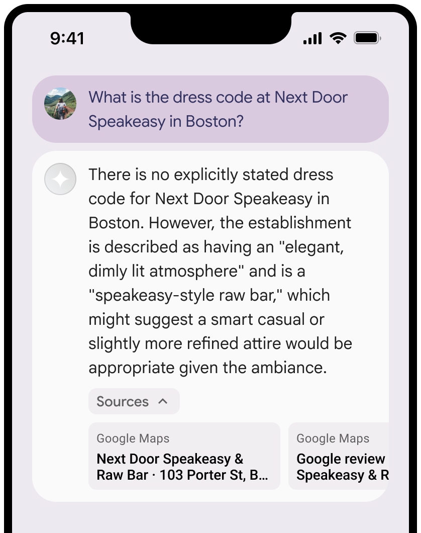
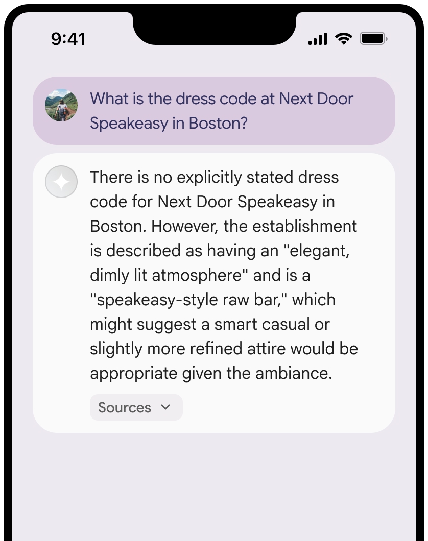
You can collapse the view of the sources.
Optionally, you can enhance the link preview with additional content, such as:
- A [Google Maps favicon](https://www.google.com/images/branding/product/ico/web_maps_icon_32dp.ico) inserted before the Google Maps text attribution.
- A photo from the source URL (`og:image`).
For more information about some of the Google Maps data providers and their
license terms, see the
[Google Maps and Google Earth legal notices](https://www.google.com/help/legalnotices_maps/).
### Google Maps text attribution guidelines
When you attribute sources to Google Maps within text, follow these
guidelines:
- Don't modify the text `Google Maps` in any way:
- Don't change the capitalization of the text `Google Maps`.
- Don't wrap the text `Google Maps` onto multiple lines.
- Don't localize the text `Google Maps` into another language.
- Prevent browsers from translating the text `Google Maps` by using the HTML attribute `translate="no"`.
- Style the text `Google Maps` as described in the following table:
| Property | Style |
|---|---|
| Font family | Roboto. Loading the font is optional. |
| Fallback font family | Any sans serif body font already used in your product or "Sans-Serif" to invoke the default system font |
| Font style | Normal |
| Font weight | 400 |
| Font color | White, black (#1F1F1F), or gray (#5E5E5E). Maintain accessible (4.5:1) contrast against the background. |
| Font size | Minimum font size: 12sp Maximum font size: 16sp To learn about sp, see Font size units on the [Material Design website](https://m3.material.io/styles/typography/type-scale-tokens#3f4488e7-3b74-45b0-a143-9d6afa4d62dc). |
| Spacing | Normal |
#### Example CSS
The following CSS renders the text `Google Maps` with the appropriate
typographic style and color on a white or light background.
```css
@import url('https://fonts.googleapis.com/css2?family=Roboto&display=swap');
.GMP-attribution {
font-family: Roboto, Sans-Serif;
font-style: normal;
font-weight: 400;
font-size: 1rem;
letter-spacing: normal;
white-space: nowrap;
color: #5e5e5e;
}
```
### Caching of place ID
The *Google Maps Grounded Result* might include a place ID. You can cache,
store, and export the following response data:
- `placeId`
The restrictions against caching in the Grounding with Google Maps Terms don't
apply to this data.
### Prohibited activity and territories
Grounding with Google Maps has additional restrictions for certain content
and activities to maintain a safe and reliable platform. In addition to the
usage restrictions in the Terms for your chosen Gemini API provider:
[Gemini Developer API](https://ai.google.dev/gemini-api/terms#grounding-with-google-maps)
or Agent Platform Gemini API (formerly Vertex AI) (see
[Service Terms](https://cloud.google.com/terms/service-terms)
section within the Service Specific Terms).
- You won't use Grounding with Google Maps for high risk activities
including emergency response services.
- You won't distribute or market your application that offers Grounding
with Google Maps in a Prohibited Territory. For more information, see
[Google Maps Platform Prohibited Territories](https://cloud.google.com/maps-platform/terms/maps-prohibited-territories).
The list of Prohibited Territories may be updated from time to time.
### Grounded results and AI monitoring in the Firebase console
If you've enabled
[AI monitoring in the Firebase console](https://firebase.google.com/docs/ai-logic/monitoring.md.txt#ai-monitoring-in-console),
responses are stored in Cloud Logging. By default, this data has a 30-day
retention period.
It's your responsibility to ensure that this retention period, or any custom
period you set, fully aligns with your specific use case and any additional
compliance requirements for your chosen Gemini API provider:
[Gemini Developer API](https://ai.google.dev/gemini-api/terms#grounding-with-google-maps)
or Agent Platform Gemini API (formerly Vertex AI) (see
[Service Terms](https://cloud.google.com/terms/service-terms)
section within the Service Specific Terms). You may need to
[adjust the retention period in Cloud Logging](https://cloud.google.com/logging/docs/buckets)
to meet these requirements.
## Pricing and rate limits
Grounding with Google Maps pricing is based on queries. A request is only
counted towards the Google Maps quota when a prompt successfully returns
at least one *Google Maps Grounded Result* (meaning the response contains
at least one Google Maps source). If multiple queries are sent to
Google Maps from a single request, it counts as one request towards the
rate limit.
Make sure to review details about pricing, model availability, and limits for
Grounding with Google Maps in your chosen Gemini API provider
documentation:
[Gemini Developer API](https://ai.google.dev/gemini-api/docs/pricing)
\|
[Agent Platform Gemini API (formerly Vertex AI)](https://cloud.google.com/gemini-enterprise-agent-platform/generative-ai/pricing).